


Project NOAH

Project NOAH介绍
Project NOAH for Android
Enabling the mobility of Project NOAH. The official mobile version (native Android) of Project NOAH website (noah.dost.gov.ph) though without the Flood Map features.
This mobile app was developed by Rolly Rulete in cooperation with Project NOAH and with the partnership of Smart Communications, Inc. through the Smart Developer Network (SMART DevNet). Content and data come from the Department of Science and Technology (DOST) and its participating agencies.
Project NOAH’s (Nationwide Operational Assessment of Hazards) mission is to undertake disaster science research and development, advance the use of cutting edge technologies and recommend innovative information services in government's disaster prevention and mitigation efforts. Though the use of science and technology and in partnership with the academe and other stakeholders, the DOST through Program NOAH is taking a multi-disciplinary approach in developing systems, tools, and other technologies that could be operationalized by government to help prevent and mitigate disasters.
FEATURES:
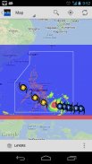
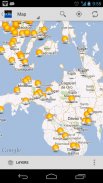
1. Map View
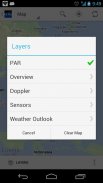
- PAR (Philippine Area of Responsibility)
- Overview (MTSAT, Rainfall Contours, Chance of Rain, etc)
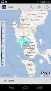
- Doppler (Subic, Tagaytay, Cebu, Hinatuan, Tampakan)
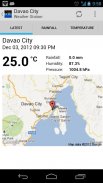
- Sensors (Weather Stations, Stream Gauges, Rain Gauges, Tide Levels)
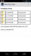
- Weather Outlook (Probablity of Rain, PAGASA Typhoon Forecast)
2. List View
- Almost the same with Map View but presented as list for ease of use.
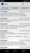
3. News
- DOST-PAGASA
- ClimateX
- PAGASA-FFWS (Flood Forecasting and Warning Section)
4. Help
- Help articles and guidelines
5. Info
- Information Dashboard
- Useful links and contents
* plus status notifications for "Probability of Rain"
* share screenshot (in almost all views) or text contents (News) via applications (Facebook, Twitter, Instagram, Bluetooth, Gmail, etc)
* the app is themeable! (Holo Light [default theme] OR Holo Dark)
* supports animated overlays (MTSAT, Doppler, Chance of Rain)
* improved caching for performance and offline usage
* very flexible Settings
keywords: DOST, PAGASA, NOAH, NDRRMC, nababaha, ClimateX, MMDA, SMART, SMART DevNet
</div> <div jsname="WJz9Hc" style="display:none">为Android项目NOAH
挪亚项目启用的流动性。官方手机版(原生Android)项目诺亚网站(noah.dost.gov.ph)虽然没有洪水地图功能。
此移动应用程序开发合作项目NOAH和伙伴关系,Smart通信公司通过智能开发人员网络(SMART DEVNET)由Rolly的Rulete的。内容和数据来自科学与技术系(DOST)及其参与机构。
项目诺亚(全国业务评估危害)的使命是进行灾害科学的研究和发展,推进尖端技术的使用,并建议创新的信息服务,在政府的防灾和减灾努力。虽然使用科学和技术,与学术界和其他利益相关者合作,通过程序NOAH外轮理货采取多学科的方法,系统开发,工具和其他技术可能具有可操作性的政府,以帮助预防和减轻灾害。
特点:
1。地图视图
- PAR(菲律宾责任范围)
- 概述(MTSAT,等雨量线,晴间多云,等)
- 多普勒(苏碧,大雅台,宿雾,希纳图安,坦帕坎)
- 传感器(气象站,流计,雨量计,潮位)
- 天气展望(PAGASA预测台风的雨,Probablity)
2。列表视图
- 几乎相同的地图,但作为易用性的清单。
3。新闻
- 外轮-PAGASA
- ClimateX
- PAGASA FFWS(洪水预报和警告部分)
4。帮助
- 帮助文章和指导方针
5。信息
- 信息显示板
- 有用的链接和内容
*加状态的通知“降雨概率”
*购截图(在几乎所有的意见)或文本内容(新闻)通过应用程序(在Facebook,Twitter,Instagram的,蓝牙,Gmail会等)
*应用程序是主题化! (霍洛灯[默认主题或霍洛黑暗)
支持动画叠加(MTSAT,多普勒,晴间多云)
*缓存提高性能和离线使用
*非常灵活设置
关键词:外轮理货,PAGASA,诺亚,NDRRMC,nababaha,ClimateX,MMDA,SMART,SMART DEVNET</div> <div class="show-more-end">


